Project Description
- The Klamath Hydroelectric Project (KHP) is comprised of six dams that extend from Iron Gate Dam at river mile 190 (RM 190) to Link River Dam at the outlet of Upper Klamath Lake (RM 245).
- All parties recognize the need to retain Link River Dam so that Upper Klamath Lake levels can be regulated to protect endangered sucker species and there is no opposition to associated, antiquated power houses being abandoned.
- J.C. Boyle Reservoir would not be removed under the preferred alternative of the FERC EIS, but flow fluctuations downstream would be reduced.
- Despite acute problems with nitorigen fixing and toxic blue-green algae identified by Tribes and water quality authorities in Copco and Iron Gate Reservoirs, FERC recommends that they also remain.
- FERC’s preferred alternative recognizes National Marine Fisheries Service (NMFS) authority to mandate installation of fish ladders at Iron Gate, Copco #1 and Copco #2 dams, which will be so costly that they will cause the KHP to lose millions of dollars annually.
The Klamath Hydroelectric Project (KHP) produces 154 MW of power. The Project was last licensed in 1956 and its license expired in March 2006. FERC’s EIS, issued in November 2007, would allow the KHP dams to remain in operation and is temporarily allowing PacifiCorp to operate on an annual license. The final KHP license cannot be issued until California and Oregon water quaity authorities give their authorization through authority under Section 401 of the Clean Water Act. State Public Utilities Commissions may also affect continued operation depending on whether they allow expenses such as fish ladders to be billed to rate payers.
Until Copco Dam was constructed in 1918, spring chinook salmon swam hundreds of miles further up the river, into the tributaries of Upper Klamath Lake, to spawn. Link River Dam was constructed in 1921, but was built with fish ladders. Copco 2 was built in 1925 to dampen the effect of peaking flows from Copco 1 (PacifiCorp, 2002b). Ironically, Iron Gate Dam was constructed for the same purpose in 1964 because releases from Copco 2 varied from 200 to 3300 cfs, which stranded fish and sometimes washed away anglers (CA AG, 1959). J.C. Boyle Dam and its associated flume and powerhouse were completed in the early 1958 and Keno Dam was completed in 1966, although related power facilities were never constructed.
All of the Lower Klamath Basin Tribes have called upon FERC to order the removal of at least four of the six KHP dams to restore fish passage and to greatly reduce Klamath River water pollution and fish diseases (Karuk Tribe, 2006; Yurok Tribe, 2006; Hoopa Valley Tribe, 2006; QVIC, 2006; Resighini Rancheria, 2006). Both state's water quality agencies have found that the Project degrades water quality, adding to nutrient and temperature problems to the Klamath River (OWRD, 2004; CSWRCB, 2004).
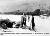
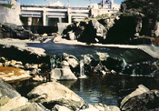
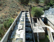
Link River Dam
Link River Dam, built in 1921, is only 16 feet high and regulates the lake level of Upper Klamath Lake. The Link River is a tiny reach of the Klamath River extending just a mile to Lake Ewauna at the edge of Klamath Falls, Oregon. PacifiCorp (2004) plans to abandon the Eastside and Westside powerhouses on the Link River and drop Link River Dam from its relicensing application.
The U.S. Bureau of Reclamation (BOR) owns Link River Dam, the point of diversion for the federal Klamath Irrigation Project's A-Canal. BOR regulates Klamath River flow by shunting more or less water away from the river into the canal (PacifiCorp, 2002d).
Problems with fish screens at Link River Dam have been noted by the State of Oregon (OWRD, 2004): "Significant entrainment of fish, including federally-listed Lost River and shortnose suckers, has been documented in 1997-1999 at the Link River Dam hydroelectric facilities (Gutermuth et al. 2000)."
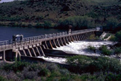
Keno Dam
The Klamath River meanders slowly for 20 miles from Lake Ewauna to Keno Dam, which was built "with the intent to produce power, but hydropower facilities were never developed." (PacifiCorp, 2002d). This reach has a very mild gradient and the 26 foot high dam results in a much slower travel rate for water, which creates conditions favorable to stream warming, increased biological activity and related water quality impairment (OWRD, 2004).
Wells et al. (2004) used existing data from ODEQ and USGS to show high biological oxygen demand, low dissolved oxygen, high pH and high ammonia levels in this reach. ODFW (1996) surveys found virtually no fish life in the Klamath River below Lake Ewauna, very low dissolved oxygen and a benthic community highly tolerant of pollution. Nutrient enrichment within Keno reservoir is boosted further by agricultural drainage from the Lost River Basin, via the Klamath Irrigation Project, entering the Klamath River through the Klamath Straits Drain (Resighini Rancheria, 2006) and when excess water is pumped from the Lost River in winter (see TMDL).
The final FERC EIS agrees with the PacifiCorp (2004) proposal to remove Keno Dam from consideration in its license. The Oregon Water Resources Department (2004, 2006), in comments for all Oregon agencies, noted that "flow manipulations at Keno Dam, to maintain upstream lake levels or to regulate riverine inflow into the J.C. Boyle Reservoir, result in significant flow variations in the Keno Reach." They also stated that: "PacifiCorp should be held accountable for Keno Dam and reservoir and associated resource impacts including exacerbation of poor water quality within Keno Reservoir caused by the impoundment of the Klamath River. FERC allowed for the Keno facility to be constructed and operated which has contributed to resource impacts. FERC should not release PacifiCorp from FERC jurisdiction for the Keno facilities until first holding PacifiCorp responsible for rectifying environmental impacts."
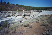
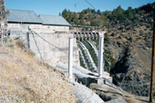
JC Boyle Dam
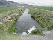
J.C. Boyle Dam is within the State of Oregon and lies five miles below Keno. The flume, which runs parallel to the Klamath River, diverts most of the flow 4.3 miles downstream to the J.C. Boyle powerhouse during summer peaking operations. ODEQ has concerns about water quality within the J.C. Boyle Reservoir and it is listed as an impaired waterbody on the 304D list for nutrients, temperature, dissolved oxygen and pH (OWRD, 2004; 2006) (see also Water Quality).
ODEQ notes that reduced flows likely cause seasonal warming in the reach effected by the bypass (OWRD, 2004). NOAA Fisheries (2003) stated that: "Adverse and often severe impacts to aquatic resources from hydro-peaking operations are well established in the scientific literature and previously documented for the J.C. Boyle Peaking Reach." There are also concerns regarding fish passage at the dam (see below).
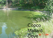
Copco 1 and 2 Dams
Copco 1 Reservoir is 5.4 miles long and has an average depth of 47 feet (PacifiCorp, 2002a). It was the first dam completed in the Project and Copco 2 below it was constructed shortly afterward. . Neither have fish ladders and NMFS is requiring that fish passage be provided if the dams are relicensed.
The National Marine Fisheries Service Terms and Conditions for KHP Operation (NMFS, 2006) states that:
"Removing the lower four dams is our recommendation to FERC under Section 10(a) of the Federal Power Act. NMFS may recommend dam removal as its preferred alternative to FERC, which it does respectfully. Section 18, on the other hand, grants mandatory authorities to NMFS to prescribe fishways (16 U.S.C., 811).... We submit our our preliminary Section 18 prescriptions with the presumption that the existing Project facilities may remain in place.... Should this be the case, it is imperative that fully volitional fishways are satisfactorily designed and implemented."
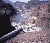
Iron Gate Dam
Iron Gate Dam was constructed starting in 1964 in order to diminish flow fluctuations due to power peaking at Copco 2, which were stranding fish (CA AG, 1959). The dam is 176 feet high and forms a reservoir that is 6.8 miles long at full pool with a surface area of 944 acres, an average depth of 62 feet and a maximum depth of 167 feet (PacifiCorp, 2002c).
When the outflow is 710 cfs, the total retention time of water in the reservoir is 42 days while during flows of 1600 cfs it is 16 days. Below 10 feet the reservoir is anoxic in summer and there has never been any provision for fish passage.
Iron Gate Reservoir is the largest in the KHP. Karuk Tribal studies (Kann and Corum, 2006) have shown that both Iron Gate and Copco reservoirs are perfect incubators for the toxic blue-green algae species Microcystis aeruginosa. Microcystis and its toxins have been measured in the Klamath River below Iron Gate all the way to the river's estuary (Yurok Tribe Environmental Program, 2006).
PacifiCorp legally challenged the NMFS' (2006) mandatory condition that they build fish ladders in a case heard in August 2006. An administrative law judge ruled in favor of NMFS, meaning that FERC must include NMFS' requirement for KHP fish ladders in any new KHP license. The final FERC EIS estimates that the KHP will loose $24 million annually after spending $200 million on fish ladders. Whether KHP dams remain depends on whether the Oregon PUC allows PacifiCorp to saddle rate payers with these expenses.
The final FERC EIS calls for leaving all KHP dams in place despite numerous problems associated with Project operations, ranging from water pollution to increasing fish disease risks and blocking salmon access to cold water refugia at a time when Klamath River salmon stocks are struggling for their survival. Learn how you can effectively protest the FERC's decision with other authorities and help get polluting KHP dams removed in time to save the salmon.
References
California Attorney General. 1959. Legal agreement between State of California and California/Oregon Power Company (Copco) regarding nuisance abatement and construction of Iron Gate Dam, dated July 27, 1959. 12 p.
California Coastal Conservancy. 2006. FERC Docket P-2082: Klamath River Project reservoirs: Interim state-agency sediment study results critical to relicensing. Appendices include Gathard Engineering. 2006. Klamath River Sediment Study. Memo from Sam Schuchat, CCC to Magalie R. Salas, FERC. California Coastal Conservancy, Oakland, CA. 104 p. VERY LARGE FILE (18.1 Mb)
California Department of Fish and Game. 2004. Additional Study Request: PacifiCorp's Final Application for New Major License Klamath Hydroelectric Project, Federal Energy Regulatory Commission (FERC) Project No. 2082. CDFG, Redding , CA. [313 Kb]
California Energy Commission. 2004. California Energy Commission Staff Comments on PacifiCorp's Final License Agreement to the Federal Energy Regulatory Commission for the Klamath River Hydroelectric Project, FERC No.2082. California Energy Commission, Sacramento , CA 44 p.[1.4 Mb]
California State Water Resources Control Board. 2004. Comments on PacifiCorp Application for New License (application) for the Klamath Hydroelectric Project (project), Federal Energy Regulatory Commission (FERC) Project #2082. SWRCB, Sacramento, CA. 25 p. [184 Kb]
G & G Associates. 2003. Klamath River Dam Removal Investigation: J. C. Boyle Dam Copco 1 Dam Copco 2 Dam and Iron Gate Dam. Funded by the California Coastal Conservancy. G&G Associates, Seattle, WA. 44 p. (607 Kb)
Guillen, G. 2003. Klamath River fish die-off, September 2002: Causative factors of mortality. Report number AFWO-F-02-03 . U.S. Fish and Wildlife Service, Arcata Fish and Wildlife Office. Arcata, CA. 128 pp. [1.1Mb] At KRIS Web site.
Gutermuth, B., C. Watson, and J. Kelly. 2000. Link River hydroelectric Project (Eastside and Westside powerhouses) final entrainment report, March 1997 – October 1999. Cell Tech Research and Development and PacifiCorp. Portland, OR. 127 pp.
Hemmingsen, A.R., R.A. French,D.V. Buchanan, D.L. Bottom, and K.P. Currens. 1992. Annual progress report of Oregon Native Trout Resources Project. Funded in part by Sport Fish Restoration funds through USFWS. F-136-R-6. Oregon Department of Fish and Wildlife, Portland, Oregon. 22 p.
Hoopa Valley Tribal Council. 2006. Klamath Hydroelectric Project (FERC #2082) Comments and Recommended 10(a) Terms and Conditions for PacifiCorp. Letter from Tribal Chair Lyle Marshall to Magalie R. Salas of FERC. Hoopa, CA. 140 p. (2.6 Mb)
Kann, J., and E. Asarian. 2005. 2002 Nutrient and Hydrologic Loading to Iron Gate and Copco Reservoirs, California. Kier Associates Final Technical Report to the Karuk Tribe Department of Natural Resources, Orleans, California. 59pp + appendices.
Kann, J. and S. Corum. 2006. Summary of 2005 Toxic Microcystis aeruginosa Trends in Copco and Iron Gate Reservoirs on the Klamath River, CA. Prepared For: Karuk Tribe Department of Natural Resources, P.O. Box 282 Orleans, CA, 95556, by Kann, J; Corum, Susan; March, 2006.
Karuk Tribe. 2006. Recommended Terms and Conditions: Klamath Hydroelectric Project, FERC License 2082-027, Operated by PacifiCorp. Submitted to FERC by the Karuk Tribe of California. Happy Camp, CA. (1.5 Mb)
National Academies of Science (NAS). 2003. Endangered and Threatened Fishes in the Klamath River Basin: Causes of decline and strategies for recovery. Prepared for the NAS by the National Research Council, Division on Earth and Life Studies, Board on Environmental Studies and Toxicology, Committee on Endangered and Threatened Fishes in the Klamath River Basin. Washington, D.C. 358 pp. [5.1Mb] At KRIS Web site.
National Marine Fisheries Service. 2004. Comments on the Draft License Application (DLA) submitted by PacifiCorps for the Klamath Hydroelectric Project (Project) (FERC No. 2082). National Oceanic and Atmospheric Administration Fisheries Div., SW Region, Santa Rosa, CA. 67 p. [414 Kb].
National Marine Fisheries Service. 2006. Comments, Recommended Terms and Conditions, and Preliminary Prescriptions for the Klamath Hydroelectric Project, FERC Project #2082. NMFS, SW Region, Long Beach, CA. 161 p.
Oregon Department of Fish and Wildlife. 1996. Summary of 1996 Klamath River sampling. Oregon Department of Fish and Wildlife, Klamath Falls, OR. 12 p.
Oregon Water Resources Department (ODWR). 2004. State of Oregon’s Comments on PacifiCorp’s Klamath Hydroelectric Project (FERC # 2082) Final License Application and Additional Study Requests. Comments from OWRD for all Oregon agencies, Salem, OR. 214 p. [4.2 Mb]
Oregon Water Resources Department (ODWR). 2006. Comments on the December 28, 2005, Notice of Application Ready for Environmental Analysis (REA) for the Klamath Hydroelectric Project (FERC 2082). ODWR, Portland, OR. 310 p.
PacifiCorp. 2004. Final License Agreement for the Klamath River Hydroelectric Project, FERC #2082. PacifiCorp, Portland, OR. http://www.pacificorp.com/Article/Article28613.html
PacifiCorp. 2002a. Copco Reservoir Water Quality Summary. PacifiCorp, Portland, OR. http://www.pacificorp.com/File/File16142.pdf
PacifiCorp. 2002b. Copco Bypass Reach Water Quality Summary. PacifiCorp, Portland, OR. http://www.pacificorp.com/File/File16799.pdf
PacifiCorp. 2002c. Iron Gate Reservoir Water Quality Summary. PacifiCorp, Portland, OR. http://www.pacificorp.com/File/File16143.pdf
PacifiCorp. 2002d. Lake Ewauna to Keno Reach Water Quality Summary. PacifiCorp, Portland, OR. http://www.pacificorp.com/File/File16150.pdf
Quartz Valley Indian Community. 2006. Klamath Hydroelectric Project, FERC No. 2082-027, Comments and Recommended Terms and Conditions for PacifiCorp. Quartz Valley Indian Reservation, Ft. Jones, CA. 57 p. (1.35 Mb)
Resighini Rancheria. 2006. Memo re: Lost River, Pre-Draft Comments on TMDL. From Phil Smith, Resighini EPA Director, to Noemi Emeric, Environmental Protection Specialists, EPA Region IX. Resighini Rancheria, Klamath, CA. 31 p. (1.9 Mb)
Resighini Rancheria. 2006. Klamath Hydroelectric Project, FERC License 2082-027, Operated by PacifiCorp Submitted to FERC by the Resighini Rancheria, a Federally Recognized Tribe. Klamath, CA. 61 p. (1.4 Mb)
Wells, S.A., R. Annear and M. McKillip. 2004. Draft Review of the Klamath River Model for the Klamath Hydropower Project FERC #2082. Performed under contract for the U.S. Bureau of Land Management and the Karuk Tribe. 130 p. [1.3 Mb].
Yurok Tribe. 2006. Comments and Recommended Terms and Conditions for Klamath Hydroelectric Project (FERC #2082). Letter from Tribal Howard McConnell to Magalie R. Salas of FERC. Yurok Tribe, Klamath, CA. 140 p. (1.1 Mb).
Yurok Tribe Environmental Department. 2006. Klamath River Blue-Green Algae Bloom Report. By Ken Fetcho, water quality specialist. Yurok Tribe Environmental Department, Klamath, California. 15 p. (854 Kb)