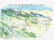
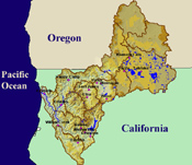
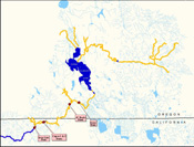
Project Location
- There are six dams in the Klamath Hydroelectric Project (KHP) in both California and Oregon.
- Nitrogen fixing algae in Upper Klamath Lake and agricultural runoff from the Lost River Basin load the KHP reservoirs with nutrients.
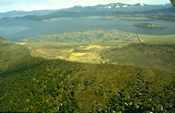
- The relatively open terrain and low relief of the landscape surrounding the reservoirs make them subject to warming and promote algae blooms.
- The KHP has blocked salmon runs to the Upper Klamath Basin since 1918, depriving the Klamath Tribes of Oregon of an important resource.
- The Tribes downstream of Iron Gate Dam have greatly diminished fishing opportunities because of poor water quality and river health, in part due to the adverse effects of the KHP on the Klamath River.
- Emissions of toxic algae growing in KHP reservoirs now poses risk to ceremonial or recreational uses downstream in the Klamath River in some months.
There are six dams within the KHP, three in Oregon and three in California. Link River Dam is at the outfall of Upper Klamath Lake; Keno Dam about twelve miles downstream; and J.C. Boyle Dam in the canyon several miles below Keno. Copco 1, and its smaller re-regulating dam, Copco 2, are just across the California border. Iron Gate Dam is located just east of the town of Hornbrook, California, where the free flowing reach of the Klamath River begins 190 miles from the Pacific Ocean
The location of the Klamath River Hydroelectric Project has a great deal to do with the water quality problems it generates. Above the project lies the hot and dry Upper Klamath Basin and highly nutrient rich Upper Klamath Lake (ODEQ, 2002). Although 38% of the Klamath Basin lies within this region, only 12% of its rainfall occurs there (NAS, 2004).
Agricultural runoff from the federal Bureau of Reclamation's Klamath Irrigation Project enters the Klamath River not only from immediately adjacent lands like Miller Island, but through a connection from the Lost River Basin created by the federal Project. A substantial portion of the water running through the KHP is agricultural drain water.
Lost River water flows to the Tule Sump where it is pumped to the Lower Klamath Marsh, and then flows through the artificial Klamath Straights Drain into the Klamath River just above the Oregon border. Water from the Lost River is also pumped into the Keno Reservoir in winter, which also contributes nutrients to Keno Reservoir that increase summer sediment oxygen demand (see TMDL page). Agricultural water demand in the Upper Klamath Basin, coupled with an arid climate, result in very low flows through the KHP in some years, which simply increases water quality problems.
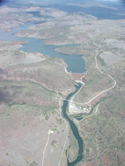
Of 62 miles of formerly free-flowing Klamath River between Iron Gate and Keno, 37 miles is now submerged by reservoirs, five miles are nearly dewatered in bypass reaches, and 16 miles are in the hydro peaking reach below J.C. Boyle where flow rates fluctuate drastically. This six mile reach below Keno Reservoir is the only reach not submerged or subjected to major flow changes.
The relatively open, flat plateaus that surround Iron Gate Reservoir and the other KHP reservoirs do not shade, but rather expose the KHP reservoir surfaces to nearly the full arc of the summer sun. Large amounts of nutrients from upstream sources enter these warm open lake environments, producing major algae blooms (see Toxic Algae page). The water leaving Iron Gate Reservoir has high concentrations of nutrients that stimulate dense growths of attached algae and aquatic plants, which, in turn, trigger water quality conditions stressful or even lethal to salmon and steelhead (see Fish Diseases page).
Much of the Klamath River watershed below Iron Gate Dam remains wild and lightly inhabited today. It flows through rugged canyons of the Klamath Mountains Geologic Province. This area includes the Ancestral Territories of several federally-recognized Native American Tribes. Some of these Tribes maintain active fisheries, which are important culturally and economically. In some years, however, the returns of salmon are so meager that Tribal fishing must be limited severely. The location of the KHP upstream from these Tribes constitutes a breach of Tribal Trust by Federal authorities because the federally-licensed KHP generates water pollution that prohibits the exercise of Treaty Rights. Recent studies have linked the decreased salmon availability to a decline in Indian health (see Study).
Although much of the Middle Klamath Basin is National Forest and tributaries are relatively healthy and cold, high nutrient concentrations from the Upper Klamath Basin extend all the way to the Klamath River estuary (see Water Quality page).
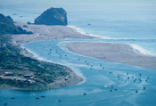
The Klamath River winds its way west from the Klamath Mountains to the Coast Range shortly before entering the Pacific Ocean near the town of Klamath, California. The very last few miles of the river are cooled by the fog from the ocean, but water temperature problems can persist even below the Trinity River's confluence with the Klamath, 40 miles inland. The Trinity does provide the mainstem Klamath some cooling flows.
The KHP is located mid-way in the migratory route of Klamath River salmon and steelhead that spawned in Upper Basin tributaries in Oregon (see range map).
References
National Academies of Science (NAS). 2003. Endangered and Threatened Fishes in the Klamath River Basin: Causes of decline and strategies for recovery. Prepared for the NAS by the National Research Council, Division on Earth and Life Studies, Board on Environmental Studies and Toxicology, Committee on Endangered and Threatened Fishes in the Klamath River Basin. Washington, D.C. 358 pp. [5.1Mb] At KRIS Web Site
Oregon Department of Environmental Quality (ODEQ). 2002. Upper Klamath Lake Drainage Total Maximum Daily Load (TMDL) and Water Quality Management Plan (WQMP). May 2002.
Resighini Rancheria. 2005. Memo re: Follow-up Comments Regarding December 16, 2004 Government-to-Government Meeting with FERC Representatives – P2082-027. From Phil Smith, Dir. Resighini EPA to Magalie R. Salas, FERC. Resighini Rancheria, Klamath, CA.